Cassandra Cosgrove (Director) and Jessica Roach (Senior Policy Officer) are leading the latest digital environmental transformation project, funded by the Digital Restart Fund - The Tree Canopy Spatial Data Project (part of the Greening our City Premier's Priority). The team shine a light on this innovative project, driving collaboration and digital solutions for a more sustainable NSW.
Q. Tree canopy - What do we officially define as a tree canopy?
A. Based on the Australian standard (AS4970-2009) a 'tree' is defined as a long lived woody perennial plant greater than (or usually greater than) 3m in height with one or relatively few main stems or trunks (or as defined by the determining authority).
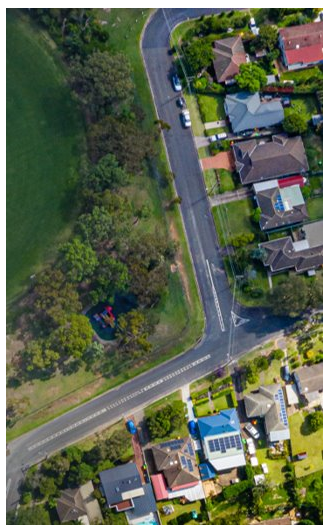
Urban tree canopy refers to trees on public and private land within urban areas. It comprises a variety of tree types such as exotics, deciduous trees, and evergreens occupying a range of environments from busy city centres to regional main streets and suburbs. Urban tree canopy is the layer of leaves, branches, and stems of trees that cover the ground when viewed from above
Q. As a customer of NSW - How does tree canopy impact my way of life?
A. In the urban environment, tree canopy not only provides shade and helps to reduce temperatures but helps mitigate the effects of climate change - especially in relation to reducing urban heat vulnerability. Research shows that urban tree canopy, together with water in the landscape, is the most effective tool in reducing urban heat. A thriving urban tree canopy contributes to places and communities that are more liveable and resilient to a changing climate with suburbs that look welcoming and encourage us to walk along the footpaths because there is shade.
Q. Tree canopy spatial data project - How did the project come to be? Was it a solution to a current problem, an opportunity or both?
A. In 2021 we held workshops with the 33 councils of Greater Sydney under the Greener Neighbourhood Program, which provides councils with financial, data and policy support to help develop and implement urban forest strategies. Feedback from councils was that there are varying levels of resourcing and support when it comes to canopy data, resulting in inconsistent canopy analysis outputs, and on-the-ground outcomes. Data is essential as it gives councils an indication of the status of their urban forest and areas of loss and gain. It also helps councils prioritise and evaluate implementation activities. A uniform dataset for Greater Sydney paired with a canopy user interface will allow for greater consistency and equity in policy making.

Q. What key elements of the project will be delivered digitally? How is this a change/improvement from the current state of play?
A. This project will deliver an innovative user interface, with greater functionality and new detailed data which hasn't been available to all Greater Sydney councils before. The new interface and subsequent granular data will allow users to drill down to the individual tree scale which is currently unavailable city-wide and allows for more informed planning and policy decisions moving forward. The current variable methods employed to collect canopy data means that analysis is difficult and may not be undertaken due to a lack of resources in some councils. This project will create an accessible, central location ensuring all councils have access to the same data, creating equity across Greater Sydney.
Q. When is go-live?
A. We expect the user interface will be ready in July 2023. We also aim to conduct two future data captures (2024 and 2026), with a view to developing state government capability to continue future canopy captures post 2026.
Q. Who are the key stakeholder groups that will benefit from the project?
A. NSW customers visiting and living in the 33 Greater Sydney Council areas, the Councils themselves and agencies across NSW Government, for example Transport for NSW, as the user interface and data will provide greater information and analytics allowing agencies to better map and plan for projects.
The current scope is Greater Sydney but in time, the aim is to leverage and deliver across NSW making this future proof and available to all.
Q. How has the Digital Restart Fund assisted with the project to date?
A. We were the successful applicants for Digital Restart Funding. The total amount is $1,000,000 to support the two key components. The first, a user interface for all 33 Greater Sydney Councils and NSW Government agencies to login, access, view and analyse data - to then make more informed project and policy decisions. Secondly, funding will also be allocated to data captures across Greater Sydney in 2024 and 2026. This will involve using aerial imagery (e.g. using a plane to capture). Currently the 33 Greater Sydney councils are acquiring their own software and canopy data at an average of $100,000 per year, equating to over $3,300,000 per year. Councils will hugely benefit out of this!
Q. In three words - How would you describe the project?
A. Innovative, Empowering, Accessible
Q. Where can we learn more about the project and keep updated?
For more information and to keep up to date with the initiative visit Greening our City or email Jessica Roach on Jessica.Roach@dpie.nsw.gov.au.