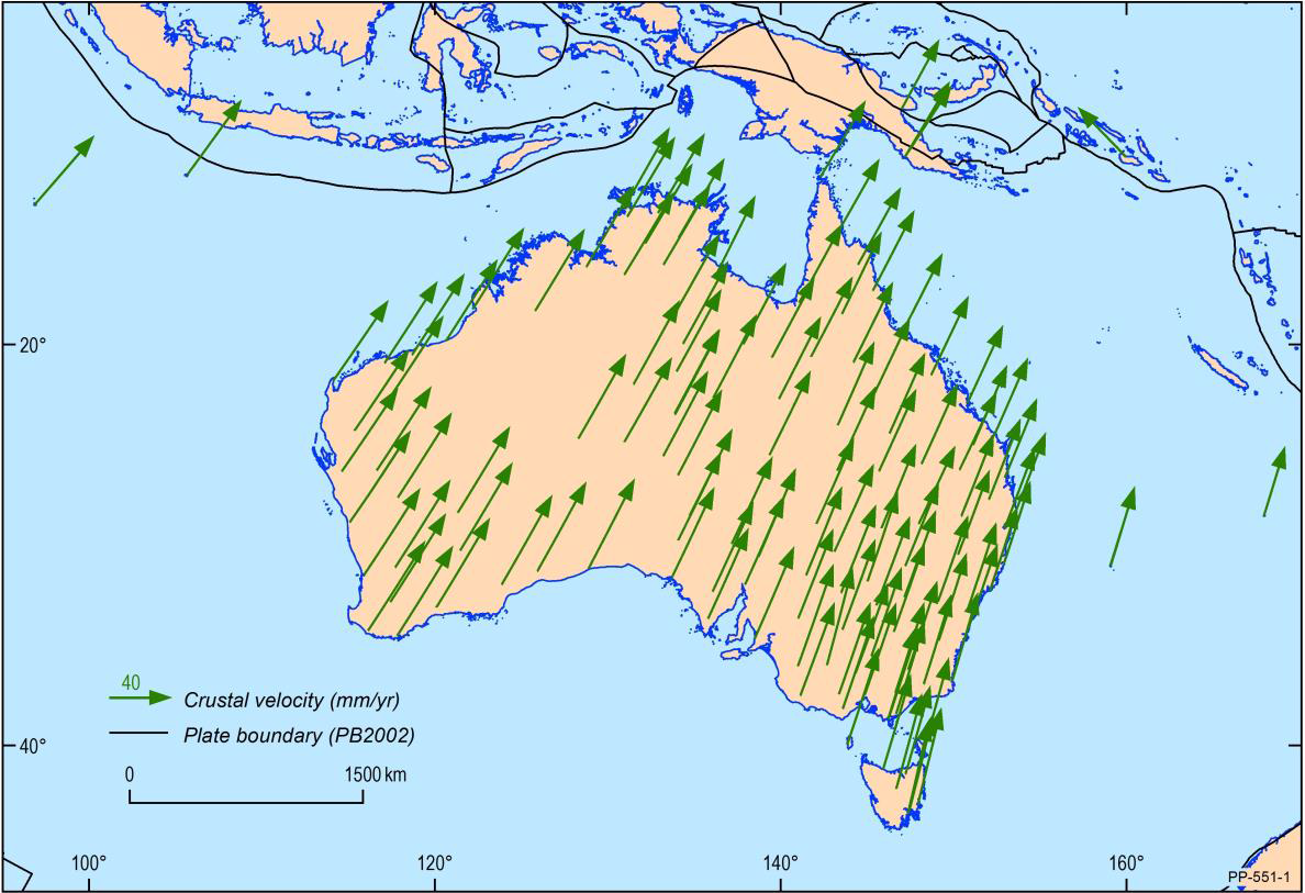
Did you know that Australia moves around seven centimetres to the north-east every year? That's almost 1.8 metres over 25 years! Australia resides on one of the Earth's most rapidly moving tectonic plates which means that our spatial data must be updated regularly, aligning with these changes, to remain accurate.
These critical adjustments are being made by NSW Government's Spatial Services through the adoption of the Geocentric Datum of Australia 2020 (GDA2020). GDA2020 will bring Australian coordinates back in line with global satellite positioning systems, and support nationally consistent positioning of the highest accuracy.

GDA2020 affects everyone
While it's not something most of us think about, we have steadily adapted to having precision GPS (or in plural, GNSS) positioning as part of everyday life. Whether it's tracking our pizza delivery, finding our way to a new address or being located by emergency services, the demand for accurate spatial data is steadily increasing. In the near future, automated vehicles (as well as those manually driven) will use precise positioning to improve the efficiency and safety of our road and transport network. As this technology progresses, the importance of accurately matching new and existing spatial data becomes even more important.
From an agricultural industry perspective, precision farming is now mainstream and acknowledged as the industry standard for increased economy, reduced input rates and improved yield monitoring. A 1.8 metre variation in this context would be significant and could cause a variety of issues, such as a failure to achieve precision sowing, to machinery accidentally overrunning cultivation paddocks and destroying fences.
Surveying, construction, emergency services and the mining industry all rely on highly accurate position and guidance solutions. Spatial Services' CORSnet-NSW provides centimetre-level accuracy to these industries throughout NSW, using internet connected devices. National initiatives are underway to provide these services directly via satellite, via an Australian-operated satellite based augmentation system (SBAS) worth approximately $250 million, as announced in the 2018 federal budget.
It is said that spatial information is the foundation of the future economy. GNSS positioning capabilities, geospatial data management, and datum modernsiation will continue to play an important in the future of NSW and Australia's economic development.
GDA2020 milestones
Changes of this magnitude don't happen overnight. Since 1994, when Australia's previous geodetic datum was adopted (25 years ago), geodetic technologies have significantly improved, resulting in nationally consistent data at an ever-increasing level of accuracy.
After a decade of development work on GDA2020 behind the scenes, 2019 is the year when NSW services and data are to be made available in GDA2020. In 2020 most users are expected to adopt and apply GDA2020.
A major milestone in GDA2020 adoption includes the recent update to CORSnet-NSW, which now delivers products and data streams in both the Geocentric Datum of Australia 1994 (GDA94) and GDA2020. This update was completed in February, synchronized with other CORS networks run by Victoria, Geoscience Australia and other local providers.
The next milestone will be the release of the Survey Control Infrastructure Management System (SCIMS) in both GDA94 and GDA2020 on 1 July. SCIMS provides high-accuracy coordinates on permanent in-ground survey marks across NSW. These survey marks are used to coordinate the legal cadastre (property boundaries) and to provide the point of truth for all other spatial applications.
Spatial Services is also planning to amend NSW legislation to support GDA2020 for all spatial applications, and to require GDA2020 coordinates on all registered survey plans from 1 January 2020.
More information
For further information on GDA2020 implementation and how it affects you, see the ICSM FAQ and Forum.